


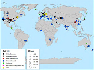
 Federal officials are wrestling with how to account for the hazard created by man-made earthquakes, many of which are triggered by oil and gas activities.
In the past, the U.S. Geological Survey has generally excluded shaking related to industrial activity from its earthquake hazard maps. The maps project the likelihood of large, natural earthquakes and are used to develop building codes, plan roads and bridges, and set insurance rates.
But amid an increase in the number and severity of man-made quakes in oil and gas regions, scientists and engineers at the agency are developing a separate map that will include what geologists call “induced seismicity.”
IMPORTANTE!: Il materiale presente in questo sito (ove non ci siano avvisi particolari) può essere copiato e redistribuito, purché venga citata la fonte. NoGeoingegneria non si assume alcuna responsabilità per gli articoli e il materiale ripubblicato.Questo blog non rappresenta una testata giornalistica in quanto viene aggiornato senza alcuna periodicità. Non può pertanto considerarsi un prodotto editoriale ai sensi della legge n. 62 del 7.03.2001.